Deutsch
  Polski
 Hydrographic and geophysical survey
GEO Ingenieurservice Group performs a variety of hydrographic and geophysical survey.
With our fleet of dedicated survey vessels equipped with state of the art survey equipment, we provide full service for high resolution hydrographic and geophysical surveys. Our well experienced and highly professional staff is flexible to work 24/7. Our survey fields range from inland waterways to nearshore installations all the way to offshore wind farms.
Depending on the requirements for each project, we use different survey methods and develop custom solutions to guarantee highly accurate and satisfying results put together in deliverables such as charts, profiles, volume calculations or 3D-views. All recorded and validated data can be consolidated and processed in GIS based solutions such as ArcGIS or Civil3D.
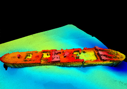
Multibeam and Singlebeam EchoSOUNDER (MBES/SBES)
Surveys with MBES ensure high resolution full coverage of the seabed and any object thereon such as pipelines or shipwrecks.
Sidescan Sonar (SSS)
The SSS acquires high resolution data for seabed classification and object detection. It is typically used as an addition to MBES as it provides detailed substrate and object information.
Sub Bottom Profiler (SBP)
The SBP records sediment layers and subsurface structures with high resolution depth profiles. Especially the new generation of parametric SBP is capable to detect extremely fine sediment layers and small buried objects.
Marine Magnetometer (MAG)
The MAG detects magnetic anomalies to identify targets like cables, pipelines and UXO. Our modern equipment ensures high quality data, available for live interpretation during a survey.